Main Menu
Our Mission is to increase women’s participation and opportunity in trail running and hiking through inspiration, education and empowerment.


Share This Article!
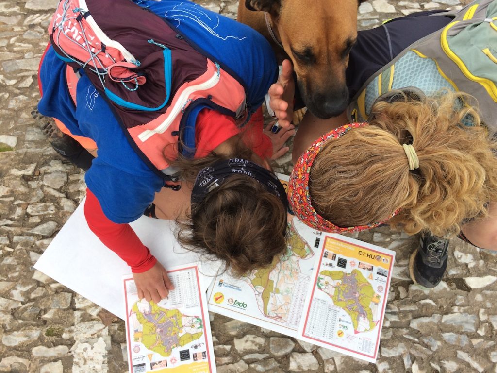
Checking my map and my compass, I quickly assess my route options. I can either gain quite a bit of elevation to get to a clean trail that will take me to the cluster of thick bushes I have to find, or I can go down just a bit, through a forest, cross a stream and climb just slightly up through a clearing to the bushes. While I can obviously run faster on the trail, I go for the latter; it’s more direct through the forest, and although off-trail, I know I’ll be able to cover ground quickly and the references are clear.
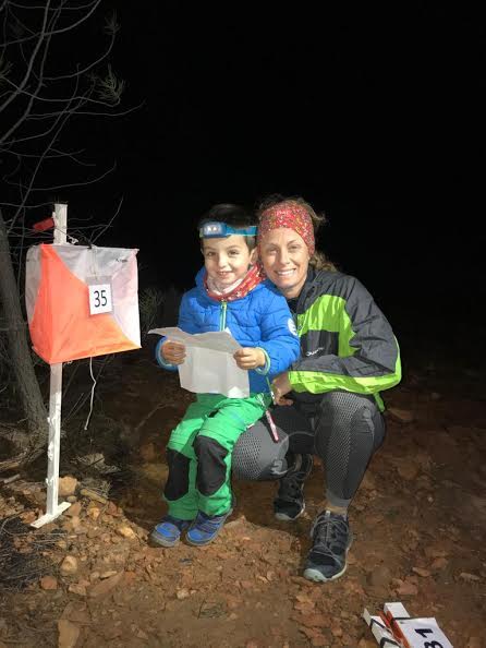
Heart racing and flooded with adrenaline, I start running as fast as I can, knowing that every second counts and doubt creeps in, “Would it have been better to go the other way?” I quickly dismiss the thought because once I’ve committed to a route, I stick to it and run as fast as I can. I try to run with the memory of the map fresh in my mind, glancing at it now and then to make sure I know where I am and looking for any references to confirm that. Arriving at the clearing, I cross it quickly to a patch of thick vegetation which just has to be the one I’m looking for and see it: a little peek of orange and white just visible through the leaves. I run around to the other side of the bushes and push my way through a thin opening. I grab the orange and white flag and take a quick look at the number on the plastic card hanging from it: 58, the number I’m looking for! I quickly insert my electronic punch card into the electronic base under the flag, hear it beep twice and see my card light up. A fleeting second of relief! Now, off to the next control point!
This is the sport of Orienteering. A high-intensity sport for nature lovers, people who like to think and run, people who want a challenge, and also people who just want to learn how to navigate with a map and do so in a setting with adequate support. This is not geocaching with a GPS unit! There is no technology allowed in orienteering to help you find your location or route.
Orienteering, in a nutshell, is using a compass and navigating with a detailed, paper map to find control points in a certain setting such as a park, mountains, a wooded area, or even an urban area, and doing this in the shortest time possible. An electronic punch card, which looks a lot like a pen drive, is “punched” into an electronic base to show that a participant visited a control point on their map. There is no set route; orienteers have to interpret the map they are given and decide their own route to visit each control and arrive at the finish. The only markers which help you know you are on the right “course” are the orange and white flags which represent the control points. Orienteers look for these along with a special code on the electronic base that corresponds to their control point and category.
In a race, orienteers have to make hundreds of split-second decisions that could cost them lots of time and standings in the classification at the end of the race. Their route choice, the terrain, their ability to move fast in certain areas, and any lapse in concentration all count towards the end result. Participants are competing against each other, but in reality, they are competing against themselves and the clock. No competitor knows how the others are doing until they finish the race and download their electronic punch card to ensure they completed the race correctly. The times determine the winner and the fastest orienteer wins.
The International Orienteering Federation (IOF) recognizes four official disciplines of orienteering: Foot Orienteering, Mountain Bike Orienteering (MTB-O), Ski Orienteering (Ski-O), and Trail Orienteering (Trail-O). However, you can also do orienteering in a kayak, swimming, on rollerblades, or even on a horse… practically any mode of getting from one point to another that isn’t motorized! There are different distances for competitions: sprints, middle distance, long-distance, and endurance races (rogaines) which can last up to 24 hours. There are also different types of courses: linear courses show the order in which you have to visit the control points, and score courses allow you to decide the order to visit the control points.
I have been competing in orienteering races since 2013, when I moved to Spain. I got hooked after participating in an 8-hour foot race called a Rogaine with my husband, brother-in-law, and good friend. We ended up running 42km, but based on our own route and strategy- running through the woods, scrambling over rocks and also running on trails. I loved the energy of the sport! Spending the day in the mountains or outdoors, deciding the way from one point to the next and finding the control point became an addiction. I also love not knowing where I am in the standings because everyone’s strategy is different! After the races, the ambiance is always humming with excitement: the people get together and share their strategies, good moments, and difficult moments. You really bond with the people you compete against and are constantly learning.
The community of orienteering is welcoming and full of every type of person you can imagine. There are people who race competitively, but who love sharing tips on how to improve and interpret the terrain faster and better. There are also people who come to just enjoy nature with their families and learn how to use a map. In the end, orienteering is for everyone of all ages!
What has orienteering given me specifically? The ability to interpret a map and the terrain and navigate through the wilderness. I notice things about the terrain that maybe before seemed unimportant, but help me know where I am at all times. It’s also given me the confidence to start planning my own adventures and to do so by myself, being self-sufficient. Learning how to navigate with a map instead of a GPS unit is an invaluable experience in the outdoors which has given me more independence to run longer or more challenging routes, and know how to find my way if I get lost (which now I rarely do!). For women runners, this is an essential tool for empowerment! If you’d like to read more about the topic of using a map to plan your own adventures, Trail Sisters’ contributor Amelia Hagen-Dillon wrote this article about it and it is very useful!
If you’re interested in learning more about the sport of orienteering and finding a club or events near you, Orienteering USA has a website full of resources and a wonderful interactive map that shows clubs around the country. Hopefully there is one near you! For our Canadian trail sisters, visit the Canadian Orienteering Federation’s webpage which also provides an abundance of information.
The International Orienteering Federation shared this wonderful video in January 2020 that gives a great glimpse into the different disciplines in orienteering and puts images to my words, please check it out. If you’re looking to try a new activity in 2020, I hope I’ve convinced you to try this great sport!
Share This Article!
Trail Sisters® is a registered trademark of Trail Sisters LLC | © 2022 Trail Sisters LLC
2 Responses
Great article! I participated in my first adventure race (kayak, run, bike – all with orienteering and CP’s, but only 3 hours) last fall. BUT it was in an area where I’ve trained for YEARS, so I felt like I was able to find the CP’s simply by looking at the map- I knew this area like the back of my hand and it only made sense to me where they would hide the flags. But that said, NEXT month we’re doing a 10 hour AR, in a location I’m NOT familiar with, so I’m really working hard on my map and compass skills! It’s so fun diving into something totally new!
I’m so excited! I just signed up for a class on route finding and orienteering so I would know bike to find my way… I never realized that there were races like this. It sounds like so much fun!