Main Menu
Our Mission is to increase women’s participation and opportunity in trail running and hiking through inspiration, education and empowerment.


Share This Article!
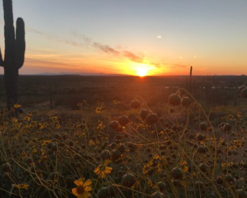
Leadville is known for its ultra-elevation, charming downtown, and the lingering “can do” spirit of the miners of the late 1800s. Although 6th Street, Hope Pass and the coordinates of a few aid stations have gained notoriety through the Leadville Race Series, there are a myriad of other remote peaks and trails to explore during a focused training session or a gentle meander. The “Cloud City” is on the bucket lists of geologists, state historians and ultrarunners worldwide, but I often count more hooved or winged companions during my runs.

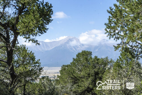
The city of Leadville is located just off of the Continental Divide, ringed by the Sawatch and Mosquito Ranges in tiny Lake County. Famous 14ers and 13ers appear in every direction, including Mt. Elbert, the highest summit of the Rocky Mountains in North America. Vail, Avon, Breckenridge, Twin Lakes, Aspen, and Buena Vista are all within an hour’s drive on a clear day, making Lake County a cost effective home base for a mountain runner who craves options.
There is no doubt that Leadville is surrounded by proper mountains. Our trails are rocky, forcing your feet to move quickly and intentionally. Expect lung-busting climbs, quad-burning descents and easy solitude (often without cellphone service.) Almost every mountain peak or pass has some sort of single-track or overgrown road weaving upwards, thanks to the miners seeking their riches a century ago. It’s not difficult to find the remains of miners’ cabins and their outbuildings — they are usually next to any icy stream, a dozen prospecting holes, and a cast iron stove from the 1920s.
Leadville itself lies in a fairly flat and wide valley. If you’re a road runner, your lungs are still acclimating to the thin air, or you just want to preserve your quads for another day, there are still opportunities to play: Highway 82 to Aspen rarely sees vehicles beyond Twin Lakes during the winter closure and the Mineral Belt Trail has 11.6 miles of easy, paved hills with interesting informational signs and viewpoints. The rocky old stagecoach road, easily-accessed from the tiny down valley town of Granite, doesn’t hold too much snow and can feel downright tropical in the spring months.
I won’t sugarcoat this: winters are long, cold and very snowy. Fences, small trees, and some roads will be buried under snow for months. As I write this at the end of February, the snow in my front yard is as tall as my shoulders. This makes maintaining a driveway miserable, but means Leadville is great for off-season cross training and winter recreation. Old mining roads make our mountains accessible for backcountry skiing and splitboarding, cross country skiing, snowshoeing, ice climbing or just hitting the slopes at Ski Cooper. An impressive network of free groomed trails covers the east side mining district during the winter. Unplowed county roads such as Halfmoon or Turquoise Lake Road, become stomping grounds for athletes and their dogs, instead of the summer’s RVs. New, used or rental equipment can be found at several locations along Harrison Avenue (without Summit or Eagle County prices.)

For those looking to run, most city and county roads are plowed winter long, without being too slippery or too busy to feel safe. I wear standard trail shoes and have *knock on wood* rarely fallen. I often run the roads or snowshoe around the woods at the Mount Massive Golf Course or historic National Fish Hatchery for some winter base-building. But even with snowshoes, “post holing” off trail through fresh snow at the golf course will challenge your hip flexors and balance. The bottom line: layer yourself in proper winter gear and make peace with all the snow between September and May.
For all those months of cold discomfort, the short summers will reward you over and over. Temperatures rarely cross 80 degrees, the afternoon monsoon storms are predictable, many trailheads are accessible by passenger vehicles, and dispersed sites and modern campgrounds abound in the San Isabel National Forest.
Clear summer roads open up interesting terrain around the Long and Derry Hill (County Road 6B and 52, and the gorgeous, isolated valley between the Empire Reservoir and Mt. Sheridan) and everything between the Champion Mine, Casco Peak and the backside of Mt. Elbert (Forest Service Roads 110 and 110J.) Give Wurtz Ditch Road (aka Wuritz Ditch, Wurts Ditch or FSR 705 near Tennessee Pass) a chance if you want miles of gentle dirt road, or follow the ridge between Mt. Zion and Buckeye Peak for spectacular views above Highway 91.
The Leadville Race Series ultrarun courses, through-hikes, burro races and backcountry hut lodging are already popular, so here are some less trodden ideas:
As you acclimate to the lack of oxygen 10,000 feet above sea level, I recommend a warm up through this landmark. Cemeteries are not for everyone, but this one’s a doozy. Modern trail runners, adventurers and “mountain folk” cannot help but respect the loneliness, tenacity and adventurous-spirit of the thousands of miners and madams buried here in the late 1800s. The sunken graves are sure to raise your hackles! Rich and poor rest side-by-side, often young victims of hard labor, disease or wintry tragedies. Your easy miles on the cemetery’s dirt roads will probably be interrupted by research, or you can take one of the Chamber of Commerce’s informative flashlight tours in the fall.
You’ll be able to get in a handful of miles without any backtracking, and the elevation is steady around 10,025 feet. Parking is available near the Veteran’s Memorial at the main gate. To extend your run, follow the paths through the woods to County Road 4 and cross over to St. Joseph’s Cemetery.
The CMC Running Club puts on occasional on-campus races, and their home trail network has easy access to the Mineral Belt trail and paths beyond. The Cloud City Wheelers maintain another network of trails just beyond campus, and some forethought can connect you through to County Roads 6 and 2, and up to the Iowa Amphitheater at the base of 14ers Sherman and Sheridan. Whether winter or summer, on fat bike or foot, the CMC campus is a great starting point for cross training or running.

The campus trails have fast and rolling hills with some tight turns, and maps at most intersections make trail navigation easy. I’m often drawn away to explore the forest beyond the trails, and have found open mine shafts and other treasures. The campus trails are between 10,000 and 10,300 feet elevation. There is ample parking at the main trailhead, or connect from one of the marked pullouts near the landfill or airport roads.
Although well-marked and drivable for the average 4×4, this explorer’s shortcut to Fairplay, Colorado sure doesn’t feel too busy for running. Head south from Leadville on Highway 24 through the Mt. Massive Lakes neighborhood, then set off on foot eastward up into the wide valley. The Weston Pass Hut could be your high-altitude home base, but it’s also satisfying to just take off on foot from the parking area at the pass. You only have to climb 50 feet to rise above 12,000, so this could be part of a strategic training run.
Leadville’s historic mining district, nestled into the Mosquito Range, has ample recreation opportunities. Ski, snowshoe, run, split-board, bike, hunt… do it all surrounded by the protected, rusty rubble of late 1800’s industry. If you head up this way, be sure to bring a map — the mining roads can be very disorienting and cell service is patchy. There are also several “roads” that start wide, then narrow and tear up tires. The real attraction is the time spent looking for hidden camps and old mines, so park low and explore on foot. Once the snow melts off, I definitely recommend a climb and descent of 13,185 foot Mosquito Pass (County Road 3) from the Diamond Mine. In fact, make this your spot for some hill sprints — your lungs will be so mad, and UTVers coming from Alma will think you’re absolutely nuts. It’s great!

Any proper summer adventure on the east side must conclude with a sunset toast on Ball Mountain. Bike, run or just drive up County Road 1 (Fifth Street) towards County Roads 1A and 1B, in the middle of the Silver Rush 50 course. Travel eastbound as far as your vehicle or feet will allow towards the bare, rounded peak. When you turn around and look west, you can see Leadville, Turquoise Lake, and 50 miles of the Sawatch range. Bring a topographic map and camera. Bring a picnic basket of goodies. Bring someone to snuggle. (Bring a coat!)
City on a Hill: A mandatory stop for early coffee, chorizo burritos and other baked goods.
Tennessee Pass Cafe: An excellent beer list and a huge menu of organic, locally-sourced foods. Bring your dogs and sit outside on a summer afternoon. Order the brussel sprouts.

El Mexicano: Fine dining in the Safeway parking lot. This food truck has a great reputation, and people line up every single day they’re open for business.
High Mountain Pies: Non-traditional pizza, done really well. Recipes include clams, butternut squash, figs and Thai peppers. The extended time for an order of ribs is worth it.
Periodic Brewing: Although they have sandwiches and snacks, the main attraction is definitely the beer. Sample everything, then buy a tiny orange keg and tap for the next adventure.

Leadville Outdoors: Winter gear, summer clothing and trail nutrition right on Harrison Avenue.
Community Threads: Thrift and consignment gear and clothing for all seasons and sports.
Ray of Light: A small yoga studio in a historic building with a variety of classes and local instructors.
Melanzana: Outdoor clothing, sewn right here in the Cloud City.
Strava QOM Crowns:
Hope Pass Double Crossing – North portion / South portion
County Road 2B Ascent – Bottom half / Top half
Share This Article!
Trail Sisters® is a registered trademark of Trail Sisters LLC | © 2022 Trail Sisters LLC
5 Responses
Katie, I would love to hear where you ran in Michigan! I’m always looking for more trails!!
happy trails. always!
Hi, great article, thank you. May I ask if there are reasonably long (3 to 7 miles) and reasonably flat running trails in the area (not hilly)? Can you run around Lake Turquoise? Thank you.
It’s not too hard to find (somewhat) flat runs of that length around the city grid, but they probably will be on asphalt. If you’re really looking for dirt, and don’t mind a road instead of a trail, the best flat ones I can think of are CR36 (just off of Sixth Street to the west of the park) and CR48 out by the golf course. Both are part of the 100 course. CR10, aka “Shore Pretty Drive” towards Twin Lakes, is also pretty mellow except for one switch back. It’s a mix of dirt and pavement. As soon as you leave the valley floor, you’re not gonna find anything flat for long!
You can definitely run around Turquoise Lake. The trail around the lake is part of the 100 course as well, and is right down near the edge of the water. Right now, though, everything is covered in snow… including the road. It is not plowed and is heavily used by skiers, snowmobilers and fatbikers. When the snow’s firm (morning, or during a cold snap), I’ve run it with no problem!
Hi Katie! So, I just ran the Boston marathon and in an inebriated moment decided to sign for the Leadville 50 and Marathon. I live in San Diego (don’t laugh) and need some help in trying to figure out how to train for the course. I can drive out there a few times before the races, and would love to join a running group…since I don’t know the area very well. Any suggestions of who I can contact? Thank you in advance!
Hi Veronica, congrats on toughing out Boston! Even with all of my efforts to inoculate myself from the misery, I get really, really grumpy in cold, wet running. I probably would have been dressed in my ski gear. : )
There aren’t a lot of running clubs in Leadville, unfortunately. It has always struck me as sad, given what goes down in the summer, but the reality is that there just won’t ever be that many committed runners in *any* town with such a small population. The Race Series doesn’t coordinate anything here except the camp, which bugs me as a local, but I get that there aren’t enough people around. Given all of the things that make scheduling a mountain running club difficult (work days, mileage desires, race dates, adventurous comfort zones, etc.) it feels mathematically impossible to set up a steady group of people. A good friend of mine coaches the club at Colorado Mountain College, so that age group, and their campus based runs, may or may not fit your goals.
My real advice is to just come, carry the NatGeo maps, and be content to explore by yourself. You can fill several days learning the (easily researched, easily accessed) Silver Rush and 100 courses, you’ll almost always have cell service, and you’ll run into others doing the same thing more frequently than you’d expect. If you’re on one of those courses on a June to August weekend, you won’t be alone. The lack of snow this year will make Mosquito Pass doable earlier than usual, too.
(As you get closer to planning something, you can check out local conditions from my @PbTrailReport Instagram posts… I’ll be on the SR50 course a lot, both because it’s my favorite spot ever, and I’m not sure it fits into my build up towards the 100 this year.)